The Florida Department of Transportation (FDOT), District 7 conducted a corridor planning study along a portion of Alternate US 19 (SR 595) in Pinellas County. This study focused on a segment of Alternate US 19 from Park Street North to the Pasco/Pinellas County line. The corridor is broken into two corridor segments – the southern segment begins at Park Street North and ends at Belleair Road (~11 miles in length) and the 17.9 mile northern segment stretches from Belleair Road to the Pasco County Line. The studies for the two corridor segments were conducted concurrently.
Alternate US 19 consists of several different segments, each of which vary in the land use and development patterns both along the roadway and in the surrounding areas. The purpose of the studies are to work with the community, stakeholders and a Project Advisory Group (PAG) to develop a vision and identify needs and issues. The corridor vision will guide proposed short- and long-term recommendations. These may include issues relating to capacity, traffic operations, safety, access and egress, freight movements, transit, bicycles, and pedestrian movements.
Phases of the Study
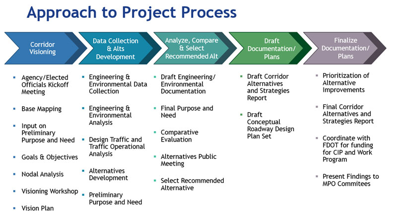
The study was broken down into three phases, each with its own technical and public involvement focus.
PHASE 1 – Developing a Corridor Vision
We listened to the community’s desire and used this input to help shape the corridor vision, which informed the study’s approach. Public outreach activities during this phase included:
- USER PREFERENCE SURVEY: As part of the outreach during this phase, we asked for feedback through a survey about the future of the Alternate US 19 corridor.
- VISIONING CHARRETTES: A series of visioning charrettes were held in June 2017. The purpose of the charrettes was to obtain insights from the community leaders and residents to help develop a vision for the future of the Alternate US 19 corridor.
- VISIONING WORKSHOPS: The findings from the visioning charrettes were presented to the public at two visioning workshops held in December 2017. The study teams also solicited input from participants to help further refine the corridor vision.
Concurrent with the public outreach efforts, the project team gathered technical data on how the existing corridor is used. The findings of the technical analysis and a summary of public comments garnered through the user preference survey and visioning charrettes were presented at the two visioning workshops.
PHASE 2 – Develop/Refine Corridor Alternatives
The project team developed a variety of short- and long-term solutions to improve mobility and safety within the project corridor, and engaged the community in refining design options through continued meeting of the Project Advisory Group and an Alternatives Public Workshop held in September 2018. The public offered ideas and comments on what options they preferred.
PHASE 3 – Corridor Alternatives and Strategies Report
A Corridor Alternatives and Strategies Report (CASR) was developed at the conclusion of the study. The CASR outlines a series of guiding goals and objectives, and identifies a range of multi-modal solutions to address the mobility needs along the corridor within a context that reflects the long-term vision for the study corridor.
The CASR includes short and long-term strategies that guide future development within the corridor, as well as specific improvements that can potentially be advanced in the near term though local agency participation and/or by FDOT as Resurfacing, Restoration, Rehabilitation (3-R) projects, safety enhancements or traffic operations signal re-timing projects.

