On December 6, 2022, the Florida Department of Transportation (FDOT), and FDOT’s Office of Environmental Management (OEM) pursuant to 23 U.S.C. 327 and a Memorandum of understanding (MOU) dated May 26, 2022, and executed by Federal Highway Administration (FHWA) and FDOT, granted Location Design Concept Acceptance (LDCA) for the US 98/State Road (SR) 35/SR 700 Project Development and Environment (PD&E) Study from CR 54 to US 301/SR 39. It is located in Pasco County and is approximately 8.6 miles.
The environmental review, consultation, and other actions required by applicable federal environmental laws for this project are being, or have been, carried out by the Florida Department of Transportation (FDOT) pursuant to 23 U.S. C. §327 and a Memorandum of Understanding dated May 26, 2022 and executed by the Federal Highway Administration and FDOT.
Click here to view the Study Approval Notification.
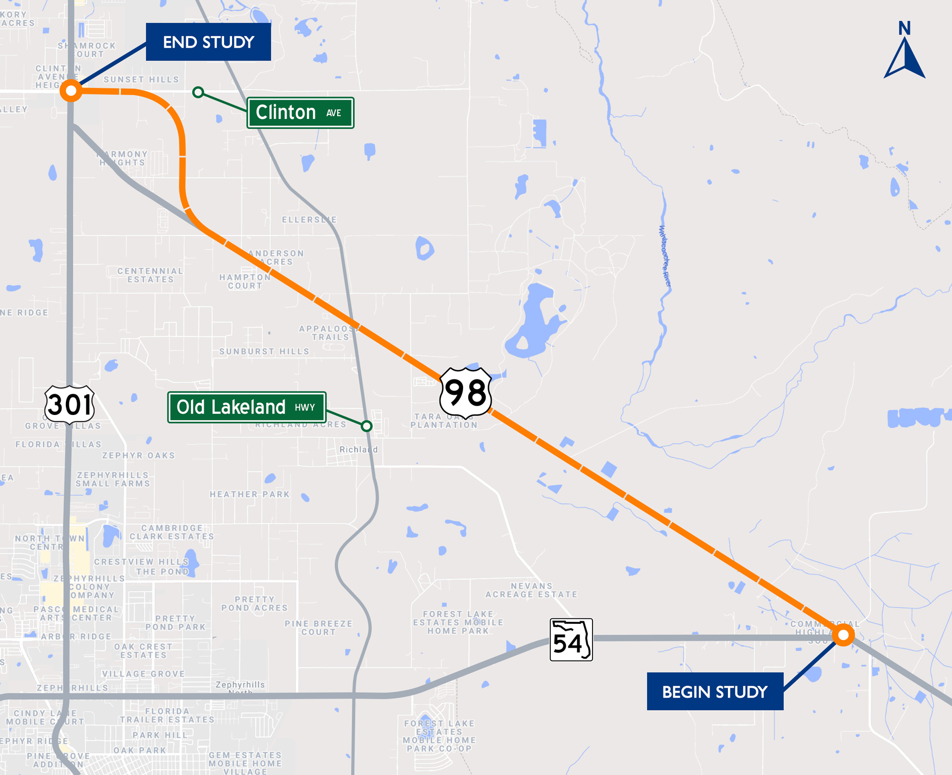
The Florida Department of Transportation (FDOT) conducted a Project Development and Environment (PD&E) Study for the widening of US 98 (SR 35/ SR 700) from two lanes to four lanes from the Polk County Line / CR 54 to US 301 (SR 39/SR 41) which included the realignment of US 98 (SR 35/SR 700) between CR 35A to US 301 (SR 39/SR 41). The realignment allowed US 98 to align with the Clinton Avenue (New SR 52) intersection at US 301 and was the result of a separate Alternatives Corridor Evaluation [ACE] study. The study was located in unincorporated Pasco County and Dade City, FL, and was a distance of approximately 8.6 miles. The project limits are shown on the project location map above.
The objective of the project was to develop and evaluate “Build” alternative(s) and provide the environmental and engineering analyses and documentation for the FDOT to reach a decision on the type, conceptual design, and location of the improvements. The “No-Build” or “No Action” alternative remained a viable option throughout the PD&E Study.
Project Purpose
The purpose of this project was to evaluate the realignment of US 301 at US 98 and Clinton Avenue to enhance safety and provide system linkage/regional connectivity.
Project Need
A realignment of US 98 intersection to align with the Clinton Avenue (New SR 52) intersection was needed to eliminate the existing closely spaced intersections along US 301, to reduce crashes, and to enhance safety. Construction of the realignment of SR 52 from east of McKendree Road to east of US 301 began in 2019 and will serve as an additional east/west route in the regional transportation network. When completed, this improvement will increase traffic at the US 301 at US 98 and US 301 at Clinton Avenue intersections, exacerbating the current intersection safety concerns. Also, a study is currently underway for the widening of US 98 from north of West Socrum Loop Road to South of CR 54 (Financial Management No.: 436673-1-22-01). This study addressed capacity needs for the final segment of US 98 connecting to US 301 (which is a designated regional freight mobility corridor) as well as operational improvements to the intersection of US 98 and US 301 ultimately resulting in enhanced transportation network connectivity.
Project Status
FDOT District Seven initiated the Alternatives Corridor Evaluation (ACE) process for the US 301/US 98/Clinton Avenue Intersection Realignment Study in Pasco County, Florida in April 2019 and it was completed in January 2021. The realignment of the US 98 intersection was listed in both the Needs Plan and the Cost Feasible Plan of the Pasco County MPO’s 2045 Long Range Transportation Plan (LRTP). The project was ranked #14 (Work Program Item (WPI) Segment #443368-1) on the Pasco County Metropolitan Planning Organization’s (MPO’s) 2020 Transportation Improvement Program (TIP) Priority List: Table 1: Combined Roadway Capacity, Intersection, ITS Projects, and Regional Trails. The realignment was also listed on the current State Transportation Improvement Program (STIP) for the Project Development and Environment (PD&E) and Design phases.
The FDOT coordinated with Pasco County and the Pasco MPO to ensure that the project was consistent with the local government comprehensive and transportation plans.
System Linkage
US 98 is a regional corridor which provides a connecting link between Polk and Pasco Counties and, within the area, provides a connection to the cities of Lakeland and Bartow to the south.
US 98 is the longest road in Florida and spans from Pensacola to Palm Beach primarily traveling along the Gulf Coast. Plans are currently underway for the widening of US 98 from north of West Socrum Loop Road to South of CR 54 (Financial Management No.: 436673-1-22-01). This project will provide additional capacity for the final segment of US 98 connecting to US 301 ( as well as operational improvements to the intersection of US 98 and US 301 ultimately resulting in enhanced transportation network connectivity. Currently, this segment of US 98 experienced truck volumes in excess of 23% of annual average daily traffic (AADT) which illustrates this facility’s importance to the overall freight network within the State of Florida.
Safety
A total of 211 crashes were documented between 2014 and 2018 along this corridor. Approximately 36% were rear end crashes, which is a crash type typically related to “stop-and-go driving” conditions and is indicative of traffic congestion. Of the 211 total crashes, there were three fatal crashes, 109 crashes involving personal injury, and 99 crashes that were property damage only.
The closely spaced intersections of US 301 at US 98 and US 301 at Clinton Avenue have crash rates that exceed the statewide average. The intersection of US 301 at US 98 experienced a total of 63 crashes, a crash rate (0.816 crashes per million entering vehicles) that was consistently higher than the statewide average (0.270) for a similar type of intersection, resulting in a crash ratio of 3.022 (crash rate divided by statewide average crash rate). The intersection of US 301 and Clinton Avenue experienced a total of 65 crashes, a crash rate (1.259) that was consistently higher than the statewide average (0.526) for a similar type of intersection, resulting in a crash ratio of 2.394. A realignment of US 98 to Clinton Avenue to eliminate high traffic volumes at one of the two closely spaced intersections has the potential to reduce crashes and enhance safety.
The intersection of US 98 and CR 54 experienced a total of 6 crashes. This intersection exhibited a crash rate (0.483 crashes per million entering vehicles) that was consistently higher than the statewide average (0.273) for a similar type of intersection resulting in a crash ratio of 1.769 (crash rate divided by statewide average crash rate).
Proposed Improvements
This project realigned US 98 (SR 35/SR 700) with the Clinton Avenue (New SR 52) intersection to better facilitate east-west traffic in Central Pasco County and the widening of US 98 from two lanes to four lanes from CR 54 to US 301.
US 98 is a two-lane undivided facility and is functionally classified as an urban principal arterial. The realignment eliminated the existing closely spaced major intersections along US 301, to reduce crashes, and to enhance safety. In addition, the project included improvements to bicycle and pedestrian facilities. Currently, there are no pedestrian or bicycle facilities along US 98, but sidewalks on the north and south side of Clinton Avenue at the approach to the intersection with US 301. Also, bicycle lanes begin approximately 1,200 feet east of the Clinton Avenue and US 301 intersection.
Clinton Avenue is a two-lane divided roadway and is functionally classified as an urban major collector. It connects to the new US 98 alignment at a new intersection.